Earthquake Activity in Ardeche, France

Quake Flash report : 2 moderate earthquakes are frightening the touristic Ardèche area in France

Last update: August 3, 2011 at 2:21 pm by By Armand Vervaeck and James Daniell

At 02:00 and at 03:36, 2 very shallow earthquakes have frightened people in the greater Nimes are. The quake was felt very well as it was very close to the surface (2 km).
The epicenter of this earthquake was almost below Barjac, a village of 1,500 people.
The quakes epicenter is located in a very busy touristic area of France, Ardèche.
Earthquake-Report.com does not expect any serious damage from this earthquake.
The map beneath shows the historic earthquakes in the area (courtesy sisfrance.net) :

The yellow dot near Ales was a strong shaking historic earthquake – map courtesy sisfrance.net

to read more (and/or access the article in French), go to:   http://earthquake-report.com/2011/08/03/quake-flash-report-2-moderate-earthquakes-are-frightening-the-touristic-ardeche-area-in-france/

X Class Solar Flares to Impact Earth 8/5

X-Class flares imminent with a solar storm on August 5th along with increased large quakes

Published on August 3, 2011 1:40 am PT
– By Jim Duran – Writer
– Article Editor and Approved – Ron Jackson


Click for larger image

(TheWeatherSpace.com) — The Sun has put out a major M-class flare directly at the planet and this will cause a solar storm on August 5th as the Sun remains unstable enough for X-class flares.

Sunspot groups on the Sun are facing the Earth and these harbor the energy for X-class flares. Major solar flares are likely from the Sun and latest magnetic field readings show one is about to erupt from the region toward the planet.

One has already erupted within the past 24 hours. Models indicate a direct hit on the Earth on and around August 5th.

“We will see an increase in earthquakes,” said TWS Senior Meteorologist Kevin Martin. “This will impact the planet hard and looking at the past events we will see a worldwide event of larger quakes.”

Martin has been following up on his solar flare vs earthquake trigger research for quite sometime and has tied numerous events to the link.

fr/http://www.theweatherspace.com/news/TWS-08_03_2011_solarquakes.html

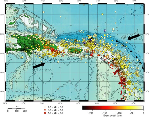
Puerto Rico Trench

Is the Massive Puerto Rico Trench Awakening?

Tue Jun 28 2011 05:58

” data-mce-href=”http://upload.wikimedia.org/wikipedia/commons/5/52/PRtrenchlocation.jpg”>File:PRtrenchlocation.jpg

by Zen Gardner

“What Puerto Rico Trench?”  Exactly.

The arrows in the map above show the direction the underlying Caribbean tectonic plates are moving, with the resultant build-up of pressure releasing into a myrid of earthquakes in the region over the years. Puerto Rico is the smaller green island in the middle, with the Dominican Republic the larger island to the left. The string of other Caribbean islands is buried under the earthquake markers that flow down the page to the lower right.

You can see the Puerto Rico Trench wraps around the entire zone.

A few little known facts came to the fore as I was researching this area after spotting the recent increase in seismic activity in the Caribbean region.

1. The Puerto Rico Trench is the biggest and deepest such trench in the entire Atlantic ocean.

2. This trench is capable of producing 8.0 earthquakes and above.

3. The risk of a major quake, underwater landslide and mega tsunami are as great as that of the Seattle area. In fact, one recent risk assessment put it at 35 to 55%!

4. The zone hasn’t ruptured in over 200 years and that has geologists seriously concerned.

to read more, go to:    http://beforeitsnews.com/story/758/858/Is_the_Massive_Puerto_Rico_Trench_Awakening.html

Canary Islands Earthquake Swarm Continues

Earthquake swarm signals volcanic activity increasing in the Canary Islands

Published on July 31, 2011 7:15 am PT
– By Jim Duran – Writer
– Article Editor and Approved – Ron Jackson


No larger image

(TheWeatherSpace.com) — The El Hierro Volcano in the Canary Islands, Spam, has been swarming with over 700 earthquakes since yesterday.

Most of the quakes have been around Magnitude 2.0 however these are tight clusters between 9 and 16 km down with some being as shallow as 4 km.

The shape of the events show a magma chamber underneath. and magma may be filling the magma chamber below the volcano as a cause.

to read more, go to:   http://theweatherspace.com/news/TWS-07_31_2011_canary.html

Earthquake Activity in Canary Islands

Earthquake activity below El Hierro volcano, Canary Islands, Spain

Last update: July 28, 2011 at 2:48 pm by By Tom Pering


Recently El Hierro volcano of the Canary Islands has been experiencing a seismic swarm beneath it, which as of yesterday reached to over 700 events.

Most of these events have been at Magnitudes of around 2 (+/-0.5) and are clustered beneath El Hierro whilst the depths of these earthquakes have been roughly between 9 and 16 km for the most part, with the exception of a few shallower and deeper quakes, the shallowest of which has been around 4 km (as of 27/04/11 8am GMT for the plotted data below) but as shallow as 1 km following this.
If we look at these earthquakes in two plots here http://www.volcano-blog.com/hierro.html we can see the clustering of these earthquakes is mainly confined to an oval area at 10 km depth.

to read more, go to::    http://earthquake-report.com/2011/07/28/earquake-activity-below-el-hierro-volcano-canary-islands-spain/


Earthquake in The English Channel

Earthquake hits English Channel

Aerial photo of southern EnglandThe earthquake was the biggest in the area for nearly 300 years

An earthquake with a magnitude of 3.9 has struck in the English Channel, the British Geological Survey (BGS) said.

The quake had a depth of 10km and its epicentre was south of Portsmouth, according to the BGS.

Residents in parts of West Sussex reported buildings shaking for a few seconds at about 0800 BST.

Sussex Police, Solent Coastguard and West Sussex Fire and Rescue Service said they had not been called out to any incidents related to it.

‘Largest since 1734’

David Kerridge, from the BGS, said it was the biggest incident of its kind in the area for nearly 300 years.

to read more, go to:    http://www.bbc.co.uk/news/uk-england-14153116

Costa Rica Earthquake

Costa Rica earthquake : numerous landslides and considerable damage

Last update: July 13, 2011 at 2:58 pm

By Armand Vervaeck and James Daniell

Earthquake overview : A strong earthquake occurred in the early afternoon in the border area of Costa Rica – Nicaragua and close to the Miravalles Volcano. Although the hypocenter was at an intermediate depth, people in the epicenter area have sustained some minor damage.

Damage inflicted after the July 12 2011 Costa Rica earthquakes.

UPDATE 13/07 – 14:54 UTC : A number of houses have been labeled inhabitable by the Costa Rican emergency services.

UPDATE 13/07 – 14:31 UTC : Just after the earthquake, villagers living near the Río Guacalito at Armenias de Upala were surprised that the river was suddenly dry! Villagers believe that a dam was created on the slopes of of the Miravalles volcanowhich dried up the river.

UPDATE 13/07 – 09:46 UTC : Due to various signs of damage and traumatized people we haveupgraded this earthquake to the CatDat Orangecategory.

to read more, go to: http://earthquake-report.com/2011/07/13/costa-rica-m56-causes-minor-damage/

Earthquake near Phillipines

Very strong coastal seaquake close to Sipalay, Negros, Philippines

Last update: July 12, 2011 at 10:03 pm by By Armand Vervaeck and James Daniell

Earthquake overview : A 6.4 magnitude earthquake struck the coastal waters of Negros Island, Philippines  at 4:47 AM local time. The epicenter of the earthquake is approx. 30 km out of the coast (USGS) and 45 km (Phivolcs). Phivolcs (the Philippines seismological service)  has not called a tsunami alarm for this earthquake as also the Magnitude was less than initially measured by USGS.

to read more, go to:    http://earthquake-report.com/2011/07/11/very-strong-coastal-seaquake-with-tsunami-danger-at-negros-philippines/

Role of Salton Sea in Earthquake Abatement

Study says Salton Sea is preventing large earthquakes

Published on July 2, 2011 12:45 pm PT
– By Dave Tole – Writer
– Article Editor and Approved – Warren Miller

(TheWeatherSpace.com) — A new scientific study, examining the fault structure of the southern San Andreas fault zone, has found that recent human regulation of the Colorado River may have delayed a major earthquake along the zone.

There hasn’t been a large earthquake under the Salton Sea for the past 300 years.

The study concludes that in the past, regular flooding of the Salton Sea area induced large earthquakes, occurring roughly every 180 years.

to read more, go to:   http://www.theweatherspace.com/news/TWS-07_02_2011_saltonsea.html

Russian Volcano Update

Russian active volcanoes (Kamchatka and Kuril Islands) weekly update (July 8)

Last update: July 8, 2011 at 4:33 pm by By Armand Vervaeck

Weekly KVERT (Russia) volcano report on the Kamchatka and Kuril Islands volcanoes (July 8).
KVERT scientists are examining satellite information each day to look for evidence of volcanic unrest since 2002.
This week listing has not changed since the July 1 listing.

The color labels are for aviation safety but are giving at the same time a perfect indication of the activity state of the volcanoes.

to read more, go to:http://earthquake-report.com/2011/07/08/russian-active-volcanoes-kamchatka-and-kuril-islands-weekly-update-july-8/