Dr. Jeff Masters on TR Chantal

Tropical Storm Chantal is strengthening as it speeds west-northwestwards at 26 mph through the Lesser Antilles Islands. At 6:22 am AST, St. Lucia recorded a wind gust of 54 mph. Sustained winds of 38 mph, gusting to 52 mph, were observed at Martinique at 10 am AST. An Air Force hurricane hunter aircraft is in the storm, and measured top winds at their 1,000′ flight level of 80 mph at 8:41 am AST, about 20 miles north of the center. Top winds seen by the aircraft’s SFMR instrument were about 60 mph, and it is likely that NHC will bump up Chantal’s top winds to at least 60 mph in their 11 am advisory. Barbados Radar shows a large area of heavy rain that has organized moderately well into low-level spiral bands affecting much of the central Lesser Antilles Islands. Chantal is not very impressive on satellite loops, though, with only a modest amount of heavy thunderstorms that are not well-organized. Only a small amount of upper-level outflow is visible. Chantal is fighting dry air associated with the Saharan Air Layer (SAL), as seen on water vapor satellite loops. Moderate wind shear of 15 – 20 knots is driving dry air into the storm. Ocean temperatures are fairly warm, at 28°C.


Figure 1. Latest satellite image of Chantal.


Figure 2. Barbados weather radar image of Chantal taken at 9:14 am AST on Tuesday, July 9, 2013. Chantal’s center was located between St. Lucia and Martinique. Image credit: Barbados Met Service.

Forecast for Chantal
Chantal will likely continue to intensify before hitting Hispaniola on Wednesday afternoon. In their 5 am EDT wind probability forecast, NHC gave Chantal a 23% chance of becoming a hurricane before hitting Hispaniola. Working against intensification will be the fast forward speed of the storm–tropical storms moving faster than 20 mph in the deep tropics usually have trouble intensifying. In addition, the Eastern Caribbean is an area where the trade winds accelerate, helping drive sinking air that discourages tropical storm intensification. Dry air will also slow down the intensification process. Interaction with the high mountains of Hispaniola and high wind shear may be able to destroy Chantal by Thursday. The 8 am EDT Tuesday wind shear forecast from the SHIPS model calls for shear to rise to the high range, 20 – 30 knots, as the storm approaches and crosses Hispaniola on Wednesday and Thursday. On Friday and Saturday, when Chantal is expected to be in the Bahamas, lower moderate wind shear of 15 – 20 knots should allow for re-intensification of the storm–if it survives interaction with the high mountains of Hispaniola, Puerto Rico, and Eastern Cuba. The latest 06Z run of the GFS model dissipates Chantal as it crosses Hispaniola, though the 00Z run done 6 hours earlier had the storm surviving. Chantal has the potential to cause big problems for Haiti, which is highly vulnerable to flash flooding due to the lack of vegetation on the deforested mountains. However, there is a lot of dry air to the west of Chantal, which may act to keep rainfall totals in Haiti down to a manageable 2 – 4″. Over 300,000 people are still homeless and living in makeshift tent camps in Haiti, three years after the great 2010 earthquake.

Chantal’s fast west-northwest forward speed of 26 mph will slow to 20 mph by Wednesday afternoon and then 10 mph by Thursday afternoon, as the storm “feels” the presence of a trough of low pressure over the U.S. East Coast. This trough will steer Chantal to the northwest and then north-northwest across Hispaniola and into the Bahamas. The trough of low pressure pulling Chantal northwards is expected to lift out the the northeast over the weekend, leaving Chantal behind off the coast of Florida. High pressure will likely build in, potentially forcing an intensifying Chantal westwards into the Florida or Southeast U.S. coast, with a possible Monday landfall.

from:      http://www.wunderground.com/blog/JeffMasters/show.html

Caribbean Earthquake 4/30 — Barbuda Area

Update 07:43 UTC : The map below shows the Shaking Intensities as reported by people to the USGS. They are confirming what we wrote below based on what our readers where reporting to Earthquake-report.com

Screen Shot 2013-04-30 at 09.42.27

Update 07:40 UTC : USGS has in the meantime decreased the Magnitude to M5.3. They have also recalculated the epicenter which is now
38km (24mi) WSW of Codrington, Barbuda
51km (32mi) NW of Saint John’s, Antigua and Barbuda
65km (40mi) ENE of Basseterre, Saint Kitts and Nevis
136km (85mi) NNW of Sainte-Rose, Guadeloupe
145km (90mi) NNW of Lamentin, Guadeloupelocated at the following distances

Update 07:38 UTC : Correspondents are talking about a moderate to strong shaking in Barbuda, Codrington.

A  strong earthquake occurred off the coast of Barbuda. As the distance of the epicenter is approx. 50 km from Barbuda, we do think that this earthquake will not generate damage on the island.
The big balloon in the map below this tect was a M7.5 earthquake which occurred in 1974! The red balloon at the top is todays earthquake.

Screen Shot 2013-04-30 at 09.08.45

40km (25mi) NW of Codrington, Barbuda
85km (53mi) NNW of Saint John’s, Antigua and Barbuda
87km (54mi) NE of Basseterre, Saint Kitts and Nevis
173km (107mi) NNW of Sainte-Rose, Guadeloupe
181km (112mi) NNW of Lamentin, Guadeloupe

Most important Earthquake Data:

Magnitude : 5.6

Local Time (conversion only below land) : Unknown

GMT/UTC Time : 2013-04-30 06:57:00

for more information and updates, go to:    http://earthquake-report.com/2013/04/30/strong-earthquake-155-miles-se-of-settlement-br-virgin-is-on-april-30-2013/

Costa Rica Dangerous Earthquake — Tsunami Risk

Massive earthquake in Costa Rica

Last update: September 5, 2012 at 3:08 pm by By

Massive earthquake in Coasta Rica
A M7.8 earthquake just occurred below the coastal area of Costa Rica
Based on the current parameters this earthquake can be called EXTREMELY DANGEROUS for everybody living in a radius of 40 km around the epicenter.
Earthquake data coming in are varying from very strong (M6.4) up to massive (M7.9)
Same goes for the depth of the earthquake, from 20 km (extremely dangerous) to 40 km (still dangerous at the max. magnitude).
We will have to wait until recalculated numbers are coming in.
The earthquake occurred on top of the North American plate which is subdected by an oceanic plate. Powerful earthquakes in the area are mostly very deep and less dangerous.

from:    http://earthquake-report.com/2012/09/04/major-earthquakes-list-september-5-2012/

Typhoon & Tropical Storm Update fr/Dr. Masters

Typhoon Roke batters Japan; Ophelia forms in the Central Atlantic
Posted by: JeffMasters, 1:28 PM GMT on September 21, 2011 +9
Typhoon Roke hit Japan near Hamamatsu at 14:00 JST Wednesday as a Category 1 typhoon with 80 mph winds. Roke brought sustained winds of 62 mph, gusting to 83 mph to the Tokyo airport at 5:25 pm local time, and a wind gust of 89 mph was reported at Shizuhama Airbase. Roke has dumped heavy rains of 155 mm (6.20″) at Hamamatsu and 125 mm (4.86″) at Tokyo. Damage due to flooding from Roke’s heavy rains will likely be the main problem from Roke, as the soils over much of Japan are saturated from the passage of Tropical Storm Talas during the first week of September. Talas was a very slow moving storm, and brought extreme rainfall amounts of over six feet to some portions of Japan. Roke brought winds less than 25 mph to the damaged Fukishima-Dai-Iche nuclear plant northeast of Tokyo, and heavy rains of 189 mm (7.50″) toHirono, located 8 miles south of the plant.


Figure 1. Radar image of Typhoon Roke as it made landfall at 14:00 JST on September 21, 2011. The typhoon brought a large area of rainfall of 50 mm/hr (2″/hr) to Japan. Image credit: Japan Meteorological Agency.


Figure 2. MODIS image of Typhoon Roke taken at 3:55 UTC on Wednesday, September 21, 2011. At the time, Roke was a Category 1 storm with 80 mph winds. Image credit: NASA.

Tropical Storm Ophelia forms in the Atlantic
Tropical Storm Ophelia formed last night in the Central Atlantic from the tropical wave (Invest 98L) we’ve been tracking this week. Satellite imagery shows that Ophelia is suffering the classic symptoms of high wind shear, with the low level center of circulation exposed to view, and the storm’s heavy thunderstorms pushed to the northeast side of the center of circulation. An analysis of wind shear from the University of Wisconsin CIMMS group shows a high 20 – 30 knots of wind shear due to strong upper level west-southwesterly winds affecting Ophelia. We don’t have any ship, buoy, or hurricane hunter observations of Ophelia’s winds, but an ASCAT pass from 7:27 pm EDT last night found top winds of 45 mph in the northeast quadrant of the storm. Ophelia will be passing south of buoy 41041 late tonight. Water vapor satellite imagesshow dry air to the the west of Ophelia, and the strong upper level west-southwesterly winds bringing high wind shear to the storm are also injecting dry air into the storm’s core, interfering with development.


Figure 3. Morning satellite image of Ophelia showing the low-level center exposed to view, with all the storm’s heavy thunderstorms pushed to the northeast side.

Forecast for Ophelia
The latest SHIPS model forecast predicts that Ophelia will experience moderate to high wind shear of 10 – 25 knots over the next five days, and will move into a region with drier air. The combination of shear and dry air should keep Ophelia from strengthening, and could dissipate the storm, as predicted by the ECMWF and HWRF models. The Northern Lesser Antilles could see some wind gusts of 30 – 40 mph and heavy rain squalls from Ophelia on Saturday and Sunday, but right now it looks unlikely that the islands would see sustained tropical storm force winds of 39+ mph, since they are likely to be on Ophelia’s weaker (dry) side. At longer ranges, Bermuda will have to keep an eye on Ophelia, since a large cut-off low pressure system over the Eastern U.S. should turn Ophelia to the northwest and then north early next week. Ophelia may eventually be a threat to Canada, but it is too early to assess the odds of this happening.

Ophelia is the 15th named storm this year, putting 2011 in 10th place for the most number of named storms in a year. Ophelia’s formation date of September 21 puts 2011 in 4th place for earliest date of arrival of the season’s 15th storm. Only20051936, and 1933 had an earlier 15th storm. With only three of this year’s fifteen storms reaching hurricane strength, though, this year has been near average for destructive potential. Atlantic hurricane records go back to 1851.

Jeff Masters

Ahh, the Life of a Pirate

Caribbean Pirate Life: Tobacco, Ale … and Fine Pottery

Owen Jarus, LiveScience Contributor
Date: 01 September 2011 Time: 10:56 AM ET
A Caribbean pirate ship
Archaeologists researching a site where Caribbean pirates “laid their hats” have found the drunken men not only smoked like the devil but also preferred fine pottery. They were sort of the real “Pirates of the Caribbean.”
CREDIT: KSL Productions LLC / Shutterstock

They smoked like the devil, drank straight from the bottle, annoyed the Spanish and had a fascination with fine pottery.

Oh, and they didn’t use plates … at least not ceramic ones.

Based in 18th-century Belize, they were real “Pirates of the Caribbean” and now new research by 21st-century archaeologists is telling us what their lives were like.

Their findings, detailed in a chapter in a recently published book, suggest that while these pipe-smoking men acted as stereotypical pirates would — drinking, smoking and stealing — they also kept fancy, impractical porcelain in their camps. The fine dinnerware may have been a way to imbue the appearance of upper-class society. [See photos of the pirate loot discovered]

Caribbean pirates

From historical records scientists had known that by 1720 these Caribbean pirates occupied a settlement called the “Barcadares,” a name derived from the Spanish word for “landing place.” Located 15 miles (24 kilometers) up the Belize River, in territory controlled by the Spanish, the site was used as an illegal logwood-cutting operation. The records indicate that a good portion of its occupants were pirates taking a pause from life at sea.

Their living conditions were rustic to say the least. There were no houses, and the men slept on raised platforms with a canvas over them to keep the mosquitoes out. They hunted and gathered a good deal of their food.

Capt. Nathaniel Uring, a merchant seaman who was shipwrecked and spent more than four months with the inhabitants, described them in the book The Voyages and Travels of Captain Nathaniel Uring (reprinted in 1928 by Cassell and Company) as a “rude drunken crew, some which have been pirates, and most of them sailors.”

Their “chief delight is in drinking; and when they broach a quarter cask or a hogshead of Bottle Ale or Cyder, keeping at it sometimes a week together, drinking till they fall asleep; and as soon as they awake at it again, without stirring off the place.” Eventually Captain Uring returned to Jamaica and, in 1726, published an account of his adventures.

to read more and see the photos, go to:    http://www.livescience.com/15866-caribbean-pirates-archaeology.html

New Tropical Wave

Potent Atlantic tropical wave could be big trouble for the United States

Published on August 17, 2011 1:05 pm PT
– By Kevin Martin – Senior Meteorologist
– Article Editor and Approved – Ron Jackson


Click for large image of tracking map

(TheWeatherSpace.com) — A disturbance in the middle of the Atlantic is moving westward and has promising features to develop into something of concern down the line.

Latest satellite images show a very broad circulation in the area. This area must be watched as the broad area has both stacked surface and mid/upper level features.

Thunderstorms should continue to form around the center of it as it moves toward the Lee and Windward Islands and strength as it does.

This was a very potent wave and was already spinning when leaving Africa so chances for a Hurricane are high with it.

As for tracking, usually I do tracking maps for these larger systems and this one looks like a United States threat, likely the Southeastern Coast.

Right now I have the tracking map (view it here) moving westward and just South (but impacting) Puerto Rico. It then moves across the Dominican Republic and enters the warm waters of the Bahamas.

to read more, go to:    http://www.theweatherspace.com/news/TWS-08_17_2011_tropicalwave.html

Puerto Rico Trench

Is the Massive Puerto Rico Trench Awakening?

Tue Jun 28 2011 05:58

” data-mce-href=”http://upload.wikimedia.org/wikipedia/commons/5/52/PRtrenchlocation.jpg”>File:PRtrenchlocation.jpg

by Zen Gardner

“What Puerto Rico Trench?”  Exactly.

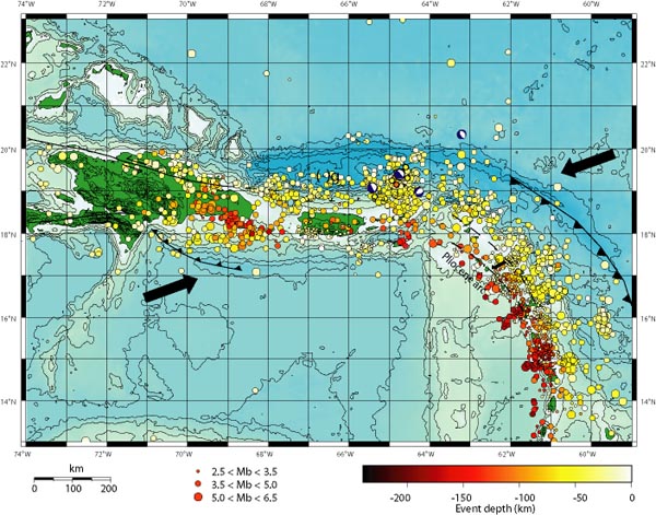
The arrows in the map above show the direction the underlying Caribbean tectonic plates are moving, with the resultant build-up of pressure releasing into a myrid of earthquakes in the region over the years. Puerto Rico is the smaller green island in the middle, with the Dominican Republic the larger island to the left. The string of other Caribbean islands is buried under the earthquake markers that flow down the page to the lower right.

You can see the Puerto Rico Trench wraps around the entire zone.

A few little known facts came to the fore as I was researching this area after spotting the recent increase in seismic activity in the Caribbean region.

1. The Puerto Rico Trench is the biggest and deepest such trench in the entire Atlantic ocean.

2. This trench is capable of producing 8.0 earthquakes and above.

3. The risk of a major quake, underwater landslide and mega tsunami are as great as that of the Seattle area. In fact, one recent risk assessment put it at 35 to 55%!

4. The zone hasn’t ruptured in over 200 years and that has geologists seriously concerned.

to read more, go to:    http://beforeitsnews.com/story/758/858/Is_the_Massive_Puerto_Rico_Trench_Awakening.html

More on Emily

Martin: What will be Emily is what I warned almost three weeks ago

Published on August 1, 2011 12:20 am PT
– By Dave Tole – Writer
– Article Editor and Approved – Ron Jackson


Click to view long range track

(TheWeatherSpace.com) — A tropical wave is moving westward toward the Puerto Rico areas this week which could be the next named system, Emily.

TWS Senior Meteorologist Kevin Martin warned the Caribbean and interests in Florida of a Cape Verde wave he saw over Africa on July 13th, which would eject out of Africa on the 24th and finally into the Caribbean around this time, the first week of August. (View that story here)

“What will be Emily is what I warned almost three weeks ago,” said Martin. “When I make a forecast that far out I tend to forget I did. Many do because this was three weeks ago. This system should impact Puerto Rico and move through Haiti, finally heading into the Bahamas by Friday and curving away from the USA just east of Florida.”

to read more, go to:    http://theweatherspace.com/news/TWS-08_01_2011_emilytrack.html