Little Green Men Spreading Monsanto GE Wheat?


(NaturalNews) There is a grand conspiracy theory at work to destroy the value of U.S. wheat crops, Monsanto recently told mainstream media reporters in a telephone conference. The contaminated GE wheat recently discovered in Oregon didn’t get there by escaping Monsanto’s open-air GMO experiments, the company claims. Instead, they say it might have been put there by a conspiracy of crop criminals who somehow acquired GE wheat from Monsanto’s field trials way back in 2005, then somehow saved it in a way that kept it genetically viable for eight years, then supposedly drove around Oregon for the sole purpose of releasing the GMOs in some farmer’s field that they just hoped the USDA might be someday be testing for GMO contamination.

That’s the far-fetched conspiracy theory now being pushed by Monsanto to explain how commercial wheat crops in Oregon got contaminated with GMOs. It was put forth by Chief Technology Officer Robb Fraley, a Monsanto executive, in a phone call with reporters.

“It seems likely to be a random, isolated occurrence more consistent with the accidental or purposeful mixing of a small amount of seed during the planting, harvesting or during the fallow cycle in an individual field,” Fraley said on the call, making him the first Monsanto executive to publicly admit he is a conspiracy theorist. He goes on to confirm that the company is investigating the possibility of “sabotage” to explain the wheat field contamination.

Did little green men spread Monsanto’s GMO seeds?

There’s only one problem with this bizarre conspiracy theory: No one knew in advance the USDA would be testing that farmer’s wheat field in Oregon. In fact, testing fields for GMO contamination is such a rare thing that the odds of a band of “conspiracy activists” correctly guessing which field was going to be tested by the USDA are at least 10,000 to 1.

To successful pull off this wild conspiracy theory being pushed by Monsanto, activists would have had to contaminate nearly ALL commercial wheat fields with genetically modified seed, and this would have involved a nationwide logistics effort of such magnitude that it would have been impossible to keep it secret. Is Monsanto really suggesting there exists a secret group of hundreds or thousands of activists driving around the country in unmarked vans, flinging Monsanto’s own wheat seeds into commercial wheat fields right at the beginning of planting season?

Or maybe it was pulled off by little green men from outer space, working in cahoots with Bigfoot, Sasquatch and the Loch Ness Monster, who all had a planning meeting in a secret underground base on the moon before deciding to focus all their efforts on embarrassing Monsanto by flinging GE wheat seeds everywhere. When they were finished, they then mutilated a few cattle and ran around conducting anal probes on some farmers just to have a little fun.

Yep, little green men did it. Because aliens hate Monsanto.

I mean, I know JFK wasn’t shot by a lone assassin. The Oklahoma City bombing was a federal operation (www.ANobleLie.com) and 9/11 was engineered and allowed to happen so that America could be stripped of its liberties and placed under a police state surveillance grid. But all those so-called “conspiracy theories” pale in comparison to the far-fetched loony bin theory of Monsanto which claims some underground group of activists has somehow been storing thousands of pounds of Monsanto’s GE wheat seeds since 1995 and has now suddenly started covertly dropping them into farm fields all across the nation. Does Monsanto not get it that anti-GMO activists do NOT want GMO seeds to grow? Planting those seeds in fields all across the country would be the very last thing they’d ever try to do, even if they did have the budgets to bank thousands of pounds of Monsanto seeds in large refrigerators for the last eight years.

The far more likely explanation in all this is that Monsanto’s open-field experiments went awry and GE wheat seeds escaped the fields in ways that Monsanto scientists didn’t anticipate (or didn’t want to anticipate).

Perhaps Monsanto would characterize that as a “conspiracy of Mother Nature.” Maybe insects are conspiring against Monsanto to spread the seeds. Maybe the wind, water and other forces of nature are “co-conspirators,” according to Monsanto.

The real conspiracy is that Monsanto is trying to dominate the global food supply

Or maybe, just maybe, it’s actually Monsanto that’s engaged in a massive conspiracy to try to dominate the global food supply by making sure its seeds genetically contaminate all commercial crop fields across America, allowing the company to sue farmers for the “theft” of intellectual property.

They’ve already done that to a multitude of farmers, by the way, so this isn’t some wild theory… it’s something that Monsanto has already been involved in.

Yep, there is a conspiracy afoot in all this, but it’s not the conspiracy Monsanto wants you to think it is. While the company claims “sabotage” in the Oregon GE wheat fields — possibly by little green men from outer space — the greater truth is that Monsanto is itself a corporation of global sabotage that destroys agriculture, contaminates the planet with genetic pollution, threatens farmers with lawsuits for planting common seeds, and then blames activists when its own dangerous experiments go haywire.

Robotic Raven

It’s a Bird, It’s a Plane, It’s … Robo Raven!

Marc Lallanilla, Assistant Editor
Date: 06 June 2013 Time: 04:24 PM
robo-raven
 A hawk attacks the Robo Raven, a remarkably lifelike robotic bird.
CREDIT: YouTube screen grab from Maryland Robotics Center

Hawks and other birds of prey are famous for their keen eyesight.

But researchers have created a robotic bird so lifelike that it’s even fooled hawks, which swoop down and attack it the way they would any other pigeonlike bird.

Developed at the Maryland Robotics Center, the robot — dubbed Robo Raven — is made of carbon fiber; 3D-printed, lightweight, thermal-resistant plastic; foam; and silvery Mylar foil (for its wings and tail), Military.com reports

obo Raven is almost 2 feet long (60 cm) and weighs less than a can of soda. Its original design was developed in 2007 by University of Maryland professors S. K. Gupta and Hugh Bruck, who carried the battery-powered bird through several evolutions before arriving at the current model.

The long lead time was necessary because, during the trial-and-error process needed to improve the robotic bird, any error would lead to a crash. This would sometimes destroy the robot, so each step in the design process was painstakingly slow.

What makes the current model so realistic is its ability to move each wing independently of the other, just as real birds do. This enables the Robo Raven to swoop, soar, dive and flap its wings in a much more aerobatic way than older models, whose wings could only move simultaneously.

“Our new robot, Robo Raven, is based on a fundamentally new design concept,” Gupta said in a news release. “It uses two programmable motors that can be synchronized electronically to coordinate motion between the wings.”

Some of the design improvements to the Robo Raven were inspired by designs found in nature. For example, the robot uses a hollow framework to provide a stiff, lightweight structure; real birds use a hollow skeletal system for the same task.

The robot is guided by a handheld radio that controls its flight. Some of the funding for the Robo Raven was provided by the U.S. Army Research Laboratory, which is investigating the Robo Raven’s possible uses for surveillance and other missions.

The Robo Raven “attracts attention from birds in the area,” John Gerdes, an engineer at the Army’s Aberdeen Proving Ground in Maryland, told Military.com.

Whereas seagulls and other birds try to fly in formation with the Robo Raven, raptors like hawks have tried to attack the bird as quarry.

“Generally, we don’t see them coming,” Gerdes said. “They will dive and attack by hitting the bird from above with their talons; then, they typically fly away.”

from:    http://www.livescience.com/37251-robo-raven-robotic-bird-fools-hawks.html

Seafloor Trash Disaster

Trash Litters Deep Seafloor, Mostly Recyclables

Becky Oskin, OurAmazingPlanet Staff Writer
Date: 06 June 2013 Time: 04:11 PM ET
ocean garbage, ocean pollution, ocean trash
 Deep-sea currents wrapped this plastic bag around a gorgonian coral almost 7,000 feet (2,115 m) below the ocean surface in Astoria Canyon, off the coast of Oregon.
CREDIT: © 2006 MBARI.

The mention of ocean pollution usually triggers searing images of birds and turtles choked by bags, fasteners and other debris floating at the ocean surface. But thousands of feet below, garbage also clutters the seafloor, with as yet unknown consequences for marine life, a new study finds.

“It’s completely changing the natural environment, in a way that we don’t know what it’s going to do,” said Susan von Thun, a study co-author and senior research technician at the Monterey Bay Aquarium Research Institute (MBARI) in Monterey, Calif.

For the past 22 years, MBARI researchers have explored the deep ocean seafloor from California to Canada and offshore of Hawaii. Video researchers tagged every piece of trash seen during the deep-sea dives, cataloguing more than 1,500 items in all. Sparked by a recent study on trash offshore of Southern California, scientists at MBARI decided to analyze the database of ocean debris they had gathered. The results were published May 28 in the journal Deep Sea Research Part I: Oceanographic Research Papers.

After reviewing every video clip that showed debris, and compiling where and when the debris was found, the researchers discovered plastics were the most common seafloor trash. [Video: Deep Sea Trash Litters the Ocean Floor]

“Unfortunately for me, I wasn’t so surprised,” said von Thun, who works in the MBARI video lab. “I’ve seen plenty of trash as I’ve been annotating video.”

More than half of the plastic items were bags. A deep-sea coral living nearly 7,000 feet (2,115 meters) off the Oregon Coast had a black plastic bag wrapped around its base, which will eventually kill the organism, von Thun said.

The second biggest source of ocean trash was metal — soda and food cans. Other common types of debris included rope from fishing equipment, glass bottles, cardboard, wood and clothing.

Because most of the ocean pollution came from single-use plastic bottles and cans, von Thun and her co-authors hope the research will inspire more people to reduce, reuse and recycle.

“The main way to combat this problem is to prevent all this stuff from getting into the ocean to begin with,” von Thun told OurAmazingPlanet. “We really have to properly dispose of items, reduce our use of single-use items and recycle.”

Changing seascape

ocean garbage, ocean pollution, ocean trash
 A discarded tire sits on a ledge 2,850 feet (868 m) below the ocean surface in Monterey Canyon off the central California coast.
CREDIT: © 2009 MBARI.

The arrival of shoes, tires and fishing gear in the deep sea is a big change for deep-sea marine life. Their environment is mostly soft mud, so hard surfaces are rare, and sea creatures colonize the trash, von Thun said. For example, MBARI is following the effects wrought by a shipping container that fell overboard into Monterey Canyon in 2004. But even a discarded tire can make a home for certain sea creatures at 2,850 feet (868 meters) below the ocean surface.

In Monterey Canyon, a deep, winding gorge offshore of Central California, trash collects in the canyon’s outer bends or in topographic highs or lows, just like in rivers on land, von Thun said. Currents also trap trash behind obstacles, such as dead whale carcasses.

“We think the canyon dynamics and the currents are actually helping to distribute the plastic and metal to deeper areas,” von Thun said.

With only 0.24 percent of Monterey Canyon explored in the past two decades by MBARI, there could be more trash hidden in the canyon’s depths, the researchers said.

from:     http://www.livescience.com/37250-trash-found-deep-ocean.html

Chromoscope 6/07

Friday, June 7:     Crazy Blue

So, once again, you have let yourself get involved with some things that you had thought you had given up.  Take time today to see what that means for you and to take action to get rid of all of that.  You have/you are moving beyond so many things right now.  To fall into someone else’s agenda and someone else’s plan is not going to benefit you.  This is a tough one, and there can be some equally tough moments today.  It is hard to make a change.  It is scary to move out of a comfort zone.  It is hell to give up the blanket, but you know, you know it has to be done.  Do it or not.  That is the question.  Today present \s you with choice, challenges and opportunities   it is up to you to see what you will do with all that.

06/05 Chromoscope

Thursday, June 6:     Dark Blue

This is a day for seeing through things.  There have been a lot of scenarios that you have built up recently, and it is time to see them for what they are.  They seem wonderful, doable, interesting, extraordinary, but deep down beneath it all, they are not you.  Today’s energies call you to connect with WHO you are.  That can be tough because right now there are so many demands being placed upon you by outside forces, and willy-nilly, you do feel the need to be nice.  Underneath it all of course, is the reality that you do not want to be nice at all, rather you would be WHO you are and do what is most positive fort yourself.  Well, you have the power.  You have the strength.  Are you brave enough?  That is always a big question.  It is time to speak you truth loudly and strongly.  You are not on this turn of the wheel for others.  It is all about you.  Take time today to know that and to know that it is okay, even better than okay to do-be, do-be, do-be, do all that is you.

Tropical Storm Andrea Forms in Gulf

The Atlantic has its first named storm of the 2013 hurricane season: Tropical Storm Andrea. An Air Force hurricane hunter plane was able to locate a closed center of circulation, and found surface winds of 40 mph in the large area of thunderstorms on the east side of the center. Satellite loops show that Andrea is a lopsided storm. It’s center of circulation is exposed to view, due to a large region of dry air that covers the entire Central and Western Gulf of Mexico. This dry air is from a trough of low pressure whose upper level winds are also creating moderate wind shear of 15 – 20 knots over Andrea. Wind shear is forecast to rise to the high range, 20 – 40 knots, by Thursday. Andrea is forecast to make landfall along the northern Gulf Coast of Florida by Thursday evening, so the system has a short window of time to intensify. Given the large amount of dry air to Andrea’s west, and the forecast for increasing shear up until landfall, I expect that the strongest sustained winds Andrea could have before landfall are 50 mph. Heavy rains will be the storm’s main threat, though a few isolated EF-0 tornadoes will also be possible in some of the heavier thunderstorms in Andrea’s spiral bands. A storm surge of 2 – 4 feet is predicted for Tampa Bay northward to Apalachicola, and rip currents will be a risk for swimmers who brave the high surf. Fort Pickens, located in Gulf Islands National Seashore on a barrier island offshore from Pensacola, Florida, has been closed to visitors due to the approaching storm. A single 2-lane road vulnerable to storm surges runs to Fort Pickens. Officials want to prevent a repeat of the situation that occurred in September 2011, when Tropical Storm Lee pushed a storm surge over the road that blocked it with sand and debris, trapping numerous campers and visitors in Fort Pickens. As of 7 pm EDT, our wundermap with the storm surge layer turned on was showing storm surge levels were less than 1 foot along the Florida coast.


Figure 1. MODIS image of Tropical Storm Andrea in its formative stages, taken at 12:20 pm EDT Wednesday, June 5, 2013, five hours before it was named. Image credit: NASA.

Andrea’s place in history
Andrea formed in a typical location for early-season storms. The Gulf of Mexico, Western Caribbean, and Bahamas are the usual areas for the genesis of June tropical storms. Andrea’s formation date of June 5 is over a month earlier than the average July 9 date for formation of the season’s first named storm. On average, the Atlantic sees one June named storm every two years. In 2012, we’d already had two named storms by this point in the season–Alberto and Beryl. This year is the second time a storm named Andrea has appeared in the Atlantic. The previous incarnation, Subtropical Storm Andrea of 2007, wandered off the U.S. East Coast in May, and never made landfall. The 2013 version of Andrea is highly unlikely to get its name retired, and we’ll be seeing a third coming of the storm in 2019.

from:    http://www.wunderground.com/blog/JeffMasters/show.html

6/5 Solar Activity

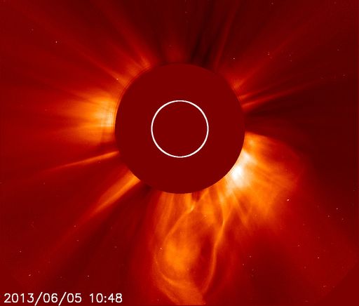
SOLAR FLARE AND CME: Southern sunspot AR1762 erupted today, June 5th, producing a long-duration M1-class solar flare that peaked around 0900 UT. The explosion hurled a right coronal mass ejection (CME) into space, shown here in a coronagraph image from the Solar and Heliospheric Observatory:

Because the sunspot is approaching the sun’s southwestern limb, the blast was not squarely Earth-directed. In fact, it might miss us altogether. Stay tuned for further analysis of the trajectory of the CME.

Meanwhile, more eruptions could be in the offing. AR1762 has a ‘beta-gamma-delta’ magnetic field that harbors energy for X-flares much stronger than the M1-class event that occured this morning.

fr/spaceweather.com

Hungary Earthquake

Moderate earthquake in Hungary

Last update: June 5, 2013 at 7:20 pm by By

Update 19:19 UTC : The epicenter of this quake is only 24 km northeast of Danube, this river which some days ago caused the heaviest flood in the German town of Passau for about 500 years. This flood is going to hit Hungary and Slovakia in the coming days. Currently some regions are flooded yet. People in social networks fear that the the dikes, which protect towns like Budapest from Danube flood, could have been damaged by the quake.

Update 19:00 UTC : Earthquake-Report.com does not expect serious damage from this earthquake. The depth will be an important parameter. Hypocenter depth is normally deep in Hungary but in some cases it may be shallow and more dangerous too.
The image below shows the seismogram as recorded by a Geofon station in Hungary.

Screen Shot 2013-06-05 at 21.00.15

Update 18:58 UTC : EMSC reports a preliminary Magnitude of 4.3 at a depth of 10 km (10 km can also mean we are not sure yet)

Update 18:57 UTC : The earthquake was also felt in Slovakia.

Screen Shot 2013-06-05 at 20.56.40

Based on an increasing number of visitors joining us from Hungary, we believe that an earthquake was felt. When you are one of the people who experienced this earthquake, please fill in the form behind “I Felt A (not Listed) Earthquake”. Thank you.

Most important Earthquake Data:

Magnitude : 3.9

Local Time (conversion only below land) : 2013-06-05 20:45:47

GMT/UTC Time : 2013-06-05 18:45:47

Depth (Hypocenter)  : 5 km

from:    http://earthquake-report.com/2013/06/05/moderate-earthquake-hungary-on-june-5-2013/

Santa Cruz Islands Aftershock

Very Strong earthquake (aftershock) at the Santa Cruz Islands

Last update: June 5, 2013 at 8:36 am by By

Update : The Focal Mechanism is Reverse Faulting = stress or accumulates pressure inside the plates. This is a subduction area were the Australian plate is subducting the Pacific plate at a speed of 10′s of mm/year. The hypocenter today (65 km depth) reflects that this is a subduction earthquake. The Santa Cruz Islands are however a complex faulting area with a lot of shallow transform faults criss-crossing the islands.

Screen Shot 2013-06-05 at 10.15.24

Update : People living in this area of the world are used (can someone be used of course ?) at very strong earthquakes. According to the USGS 8000 people will have felt a moderate MMI V shaking, noting special for the Santa Cruz Islands.

Screen Shot 2013-06-05 at 10.14.39

A late aftershock has reminded on the cruel earthquake and tsunami of last February 6 at the island of Nendo. Today’s earthquake was more to the south, but a link with the mainshock in February cannot be excluded.

Screen Shot 2013-06-05 at 10.14.28

89km (55mi) SSE of Lata, Solomon Islands
466km (290mi) NNW of Luganville, Vanuatu
725km (450mi) ESE of Honiara, Solomon Islands
734km (456mi) NNW of Port-Vila, Vanuatu
1057km (657mi) N of We, New Caledonia

Most important Earthquake Data:

Magnitude : 6.1

Local Time (conversion only below land) : 2013-06-05 15:47:25

GMT/UTC Time : 2013-06-05 04:47:25

Depth (Hypocenter)  : 42 km

from:    http://earthquake-report.com/2013/06/05/very-strong-earthquake-santa-cruz-islands-on-june-5-2013/

Earthquake offf the Big Island, Hawaii

Strong earthquake just to the south of the Big Island of Hawaii, Hawaii

Last update: June 5, 2013 at 1:03 am by By

Update 01:08 UTC :  Seismogram from the earthquake as recorded at the Hawaii Volcanoes National Park

Screen Shot 2013-06-05 at 03.07.23

Update 00:53 UTC :  MMI shaking at the most important cities

Screen Shot 2013-06-05 at 02.52.18

Update 00:51 UTC :  Weak to moderate earthquakes are normal in Hawaii and especially around the Big Island, but a strong one like today’s is rather uncommon.

Update 00:49 UTC :  The epicenter is less than a dozen miles southeast of the Loihi Seamount, the active volcano being built on the seafloor off the Ka`u coast. The depth of the hypocenter is excluding however a direct link to magmatic activity

Update 00:45 UTC :  USGS expects a maximum light MMI IV shaking and thats really good news

Screen Shot 2013-06-05 at 02.43.39

Update 00:42 UTC :  The Hawaii earthquake has been updated to a Magnitude of 5.6, unusually strong for the Islands. Aftershocks are starting to occur.  The depth however is 25 miles or 40 km and thats a depth (if true) that we can rule out any damage or injuries.

A strong earthquake happened just south of Hawaii, Hawaii and was felt all over the Islands

Screen Shot 2013-06-05 at 02.37.34

53km (33mi) SE of Pahala, Hawaii
77km (48mi) S of Hawaiian Paradise Park, Hawaii
91km (57mi) S of Hilo, Hawaii
126km (78mi) SE of Kailua-Kona, Hawaii
394km (245mi) SE of Honolulu, Hawaii

Most important Earthquake Data:

Magnitude : 5.2

Local Time (conversion only below land) : Unknown

GMT/UTC Time : 2013-06-05 00:12:40

Depth (Hypocenter)  : 16.1 km

from:    http://earthquake-report.com/2013/06/05/moderate-earthquake-hawaii-region-hawaii-on-june-5-2013/